By Zororai Nkomo
The African Union has welcomed a United Nations resolution calling for a more accurate representation of Africa on world maps, saying the initiative will help address longstanding distortions caused by the widely used Mercator projection.
The UN General Assembly adopted the resolution on Friday, with 164 countries voting in favour, one against and six abstaining. Togo spearheaded the initiative on behalf of the African Group, with the backing of the African Union.
AU Commission chairperson Mahmoud Ali Youssouf commended Togo for leading the initiative and President Faure Gnassingbé for mobilising international support.

He also praised AU member states and the African Group in New York for maintaining a united position behind the resolution.
Youssouf said the issue went beyond cartography, arguing that Africa should be represented according to objective and scientifically established realities.
He called on international institutions, schools, publishers and digital platforms to progressively adopt map projections that more accurately represent the world’s land areas.
“The African Union Commission will continue to work with Togo, member states and relevant partners to support efforts towards the implementation of this initiative,” Youssouf said.
He described the UN resolution as an important step towards changing how Africa is visually represented globally.
“Africa must be represented as it truly is: in its true dimensions and in its rightful place in the world,” he said.
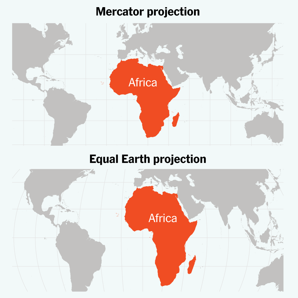
The campaign, known as #CorrectTheMap, challenges the dominance of the Mercator projection, which was developed by Flemish cartographer Gerardus Mercator in 1569 primarily for navigation.
While the Mercator projection remains useful for navigation, it distorts the relative size of landmasses, making areas closer to the poles appear much larger than they are while shrinking regions around the equator.
Africa is among the continents most affected by the distortion. On a Mercator map, it can appear similar in size to Greenland, even though Africa is about 14 times larger than the Danish territory.
One proposed alternative is the Equal Earth projection, introduced in 2018 to provide a more accurate representation of the relative size of land areas.
Supporters of the campaign say the issue is not simply about mapmaking, arguing that the way countries and continents are depicted can influence how people understand geography, history and the relative importance of different parts of the world.
Togo’s Foreign Minister Robert Dussey has described the issue as a scientific one, saying commonly used maps do not accurately portray the relative size of continents.
The African Union endorsed the #CorrectTheMap campaign in 2025 and subsequently supported efforts to take the issue to the United Nations.
The resolution is not legally binding, meaning it does not require governments, schools or technology companies to immediately abandon the Mercator projection. Instead, it encourages wider consideration and use of equal-area projections.
The campaign has also received support outside Africa, with France indicating that it will move away from the Mercator projection in favour of maps that more accurately represent land areas.